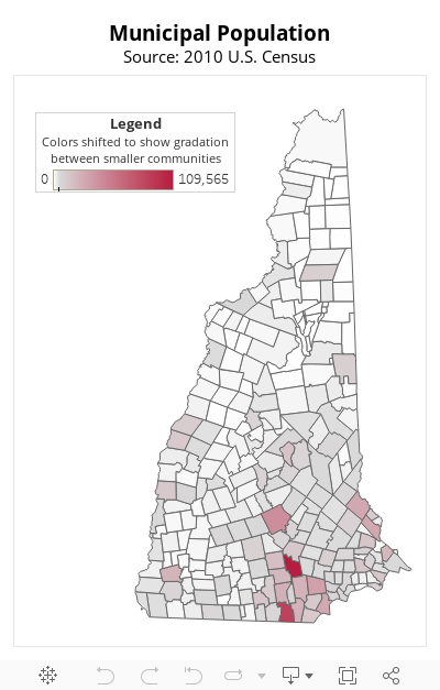
Using 2010 Census data from the U.S. Census Bureau, the map below shows population distribution across New Hampshire’s municipalities. The larger the population of the municipality, the darker the shade of red.
The larger municipal populations are located in urban areas in and around Manchester and Nashua, as well as in Concord, Rochester, Dover, and Portsmouth. Other urban centers, such as Berlin, Claremont, Conway, Keene, Laconia, and Lebanon and Hanover, are also notable in the map as the largest population centers in their respective regions. However, the map generally illustrates that the highest population municipalities in the state are located in or nearer to the greater Boston metropolitan area, and municipal populations generally decrease as distance from the southeastern portion of the state increases.
The geographic concentration of the ten most populous municipalities in the state, all but three of which are in western Rockingham and eastern Hillsborough counties, reflects the concentration of the population’s overall distribution across the state. The ten largest municipalities, which are all located in the four more urban counties in the state, included almost a third of the overall state population. Those four counties are closest to metropolitan Boston: Hillsborough County, Merrimack County, Rockingham County, and Strafford County. The two counties of these four that border Massachusetts – Hillsborough and Rockingham – have more than half of the overall state population, which was counted at 1,316,470 by the 2010 Census. The state’s six more rural counties – Belknap, Carroll, Cheshire, Coos, Grafton, and Sullivan – account for just over a quarter of the overall state population.
For more on the demographics of New Hampshire communities, including data showing regional population changes since 2010, see NHFPI’s Issue Brief Measuring New Hampshire’s Municipalities: Economic Disparities and Fiscal Capacities.